You are using an out of date browser. It may not display this or other websites correctly.
You should upgrade or use an alternative browser.
You should upgrade or use an alternative browser.
Eutelsat 7a relocation 7E -> 139.2W
- Thread starter Analoguesat
- Start date
- Status
- Not open for further replies.
- Joined
- Jul 2, 2005
- Messages
- 12,213
- Reaction score
- 12,283
- Points
- 113
- Location
- Epping Forest
- My Satellite Setup
-
OP Gibertini 100 XP+ Inverto Black Ultra Lnb
Superior Dark Motor (160° max)
(50 east to 45 west)
Octagon SX88+Optima (A/B switch) Edision primo IP S2
Raven 88cm Mesh Dish + IBU Twin output
Stab100 H to H (120° max)
(53 east to 45 west)
Octagon SX88+ Ultra HD (A/B switch) Golden Interstar Alpha_X
- My Location
- Epping Forest Essex
Thread title update to the most likely relocation of Eutelsat 7A to 33.1°east or 48°east ??
As the logical place for 7A was 5 west it seems that Eutelsat is set on moving all Italian multi-stream TV from 5 west to the very tight Italy footprint on Eutelsat 9B @ 9 east

As the logical place for 7A was 5 west it seems that Eutelsat is set on moving all Italian multi-stream TV from 5 west to the very tight Italy footprint on Eutelsat 9B @ 9 east
Last edited:
- Joined
- Jul 2, 2005
- Messages
- 12,213
- Reaction score
- 12,283
- Points
- 113
- Location
- Epping Forest
- My Satellite Setup
-
OP Gibertini 100 XP+ Inverto Black Ultra Lnb
Superior Dark Motor (160° max)
(50 east to 45 west)
Octagon SX88+Optima (A/B switch) Edision primo IP S2
Raven 88cm Mesh Dish + IBU Twin output
Stab100 H to H (120° max)
(53 east to 45 west)
Octagon SX88+ Ultra HD (A/B switch) Golden Interstar Alpha_X
- My Location
- Epping Forest Essex
EUTE 7A (EUTE W3A)
Real time satellite tracking for: EUTE 7A (EUTE W3A)
Real time satellite tracking for: EUTE 7A (EUTE W3A)
| NORAD ID: | 28187 |
| LOCAL TIME: | 19:42:01 |
| UTC: | 19:42:01 |
| LATITUDE: | 0.05 |
| LONGITUDE: | 17.72 |
| ALTITUDE [km]: | 35700.10 |
| ALTITUDE [mi]: | 22183.01 |
| SPEED [km/s]: | 3.08 |
| SPEED [mi/s]: | 1.91 |
| AZIMUTH: | 158.0 SSE |
| ELEVATION: | +28.6 |
| RIGHT ASCENSION: | 06h 28m 23s |
| DECLINATION: | -08° 20' 30'' |
| Local Sidereal Time: | 05h 11m 43s |
The satellite is in day light | |
| SATELLITE PERIOD: | 1431m |
|
pikmaxx
Member
- Joined
- Aug 24, 2010
- Messages
- 120
- Reaction score
- 185
- Points
- 43
- Age
- 47
- My Satellite Setup
- Strong 4620 reciever , 90 cm Dawlia dish
- My Location
- South of Iraq
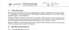
This document was published by a friend in a famous Arabian forum, it talks about Eutelsat 139 WA space debris mitigation plan, the document was originally published on the 14th of October 2019, and mentioned that Eutelsat 139 WA was launched on the 15th of March 2004, that's the exact date of Eutelsat 7A launch date, so, most likely, Eutelsat 7A is heading to 139 West and eventually will be renamed to Eutelsat 139 WA,
Interestingly, the document mentioned that the operational life of the satellite is not expected to end before mid 2025 !!!!
Interestingly, the document mentioned that the operational life of the satellite is not expected to end before mid 2025 !!!!
Attachments
sector_d
Member
- Joined
- Jul 23, 2004
- Messages
- 71
- Reaction score
- 59
- Points
- 18
- Age
- 50
- Location
- Portugal
- My Satellite Setup
-
Octagon SF4008 with RTL usb DVB-T Tuner
Clarke Tech 5000 (semi-retired), X-trend ET-9200 (semi-retired), Nokia 9600 :) (well retired)
- My Location
- Portugal
This document was published by a friend in a famous Arabian forum, it talks about Eutelsat 139 WA space debris mitigation plan, the document was originally published on the 14th of October 2019, and mentioned that Eutelsat 139 WA was launched on the 15th of March 2004, that's the exact date of Eutelsat 7A launch date, so, most likely, Eutelsat 7A is heading to 139 West and eventually will be renamed to Eutelsat 139 WA,
Interestingly, the document mentioned that the operational life of the satellite is not expected to end before mid 2025 !!!!
I've found this. It seems Eutetlsat has recently requested 139ºW orbital position exploration to the FCC.

Frequency Summary
| Lower | Upper |
|---|---|
| 10950 | 11200 |
| 11199 | 11201 |
| 11450 | 11700 |
| 11699 | 11701 |
| 12499 | 12501 |
| 12500 | 12750 |
| 13750 | 14000 |
| 14000 | 14500 |
sector_d
Member
- Joined
- Jul 23, 2004
- Messages
- 71
- Reaction score
- 59
- Points
- 18
- Age
- 50
- Location
- Portugal
- My Satellite Setup
-
Octagon SF4008 with RTL usb DVB-T Tuner
Clarke Tech 5000 (semi-retired), X-trend ET-9200 (semi-retired), Nokia 9600 :) (well retired)
- My Location
- Portugal
Its confirmed.
Eutelsat 7A will become Eutelsat 139 WA.

Eutelsat 7A will become Eutelsat 139 WA.
- Joined
- Jul 26, 2003
- Messages
- 50,809
- Reaction score
- 11,263
- Points
- 113
- Location
- Scottish Borders
- My Satellite Setup
-
TM 5402HD
Sky+ UK.
- My Location
- Scottish Borders
Thread title updated again.
- Joined
- Jul 2, 2005
- Messages
- 12,213
- Reaction score
- 12,283
- Points
- 113
- Location
- Epping Forest
- My Satellite Setup
-
OP Gibertini 100 XP+ Inverto Black Ultra Lnb
Superior Dark Motor (160° max)
(50 east to 45 west)
Octagon SX88+Optima (A/B switch) Edision primo IP S2
Raven 88cm Mesh Dish + IBU Twin output
Stab100 H to H (120° max)
(53 east to 45 west)
Octagon SX88+ Ultra HD (A/B switch) Golden Interstar Alpha_X
- My Location
- Epping Forest Essex
I am keeping an open mind for Eutelsat's 7A final location 33.1 east & 48 east seem more lightly,
If the intended location is 139 west then it would have been quicker for E7A to have gone in a westerly direction
If the intended location is 139 west then it would have been quicker for E7A to have gone in a westerly direction
- Joined
- Jul 2, 2005
- Messages
- 12,213
- Reaction score
- 12,283
- Points
- 113
- Location
- Epping Forest
- My Satellite Setup
-
OP Gibertini 100 XP+ Inverto Black Ultra Lnb
Superior Dark Motor (160° max)
(50 east to 45 west)
Octagon SX88+Optima (A/B switch) Edision primo IP S2
Raven 88cm Mesh Dish + IBU Twin output
Stab100 H to H (120° max)
(53 east to 45 west)
Octagon SX88+ Ultra HD (A/B switch) Golden Interstar Alpha_X
- My Location
- Epping Forest Essex
Hispasat 30W-4 is moving to 139 west the same destination as E7A was predicted to move to a few months ago ?

 www.satellites.co.uk
I am beginning to wonder if the info on E7A latest info is also a mistake ?
Hispasat 30W-4 at 128.5°W - LyngSat
www.lyngsat.com
Hispasat 30W-4
Hispasat 30W-4 all transponders now transferred to 30W-5 & 6 this will allow Hispasat 30W-4 to move to a new location soon, FlySat Hispasat 30W-4/30W-5/30W-6 @ 30° West
Now @ 138 westhvdh said:
Here on page 63 was the STA a few days ago that mentioned 137°W:
https://docs.fcc.gov/public/attachments/DOC-361444A1.pdf
But unfortunately, mistakes like this at FCC at not very rare.
I am beginning to wonder if the info on E7A latest info is also a mistake ?
- Joined
- Jul 26, 2003
- Messages
- 50,809
- Reaction score
- 11,263
- Points
- 113
- Location
- Scottish Borders
- My Satellite Setup
-
TM 5402HD
Sky+ UK.
- My Location
- Scottish Borders
I really hope you arent going to post a daily log of locations solly!
It will be a most tedious thread if you do.....
It will be a most tedious thread if you do.....
- Status
- Not open for further replies.