- Joined
- Jul 26, 2003
- Messages
- 51,117
- Reaction score
- 11,567
- Points
- 113
- Location
- Scottish Borders
- My Satellite Setup
-
TM 5402HD
Sky+ UK.
- My Location
- Scottish Borders
Heres a basic guide to setting up a windows plane tracking system at home.
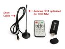
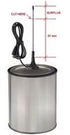
You will need a sdr dongle (available for 15-20 quid from amazon/ebay etc), an antenna cut to 1090MHz which you can build or buy - build instructions here:
Plus cabling, various interconnects etc
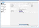
Dont be afraid to have a go - windows systems are very easy to set up - detailed instructions can be found here:
Installing the MLAT-Client on Windows – LowFlyingWales.co.uk
If you follow this exactly you will join the LowFlyingWales team and feed data to them. This is a hobby site run by enthusiasts for enthusiasts. You can add feeders for the big boys later (FlightAware, FlightRadar24 etc) once you have some experience with the software.
Once you have the basic system up and running you will want to see what its tracking and there is a superb bit of free software called Virtual Radar Server which you can connect to the feeder software to display range charts, aircraft details etc.
Home - Virtual Radar Server
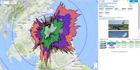
Once its all up and running you will end up with something like this with the multicoloured range splats. Im in a valley and the range rings are at 20 mile separation:

NB it is also possible to use a raspberry pi to do the basic tracking. They can be a bit tricky to set up if you havent used one before but I successfully followed these instructions to get the basic decoding going.
getting the feeder software running wasnt a great success though - every time I tried to add it in it broke something!
You will need a sdr dongle (available for 15-20 quid from amazon/ebay etc), an antenna cut to 1090MHz which you can build or buy - build instructions here:
Plus cabling, various interconnects etc
Dont be afraid to have a go - windows systems are very easy to set up - detailed instructions can be found here:
Installing the MLAT-Client on Windows – LowFlyingWales.co.uk
If you follow this exactly you will join the LowFlyingWales team and feed data to them. This is a hobby site run by enthusiasts for enthusiasts. You can add feeders for the big boys later (FlightAware, FlightRadar24 etc) once you have some experience with the software.
Once you have the basic system up and running you will want to see what its tracking and there is a superb bit of free software called Virtual Radar Server which you can connect to the feeder software to display range charts, aircraft details etc.
Home - Virtual Radar Server
Once its all up and running you will end up with something like this with the multicoloured range splats. Im in a valley and the range rings are at 20 mile separation:

NB it is also possible to use a raspberry pi to do the basic tracking. They can be a bit tricky to set up if you havent used one before but I successfully followed these instructions to get the basic decoding going.
Code:
http://tinyurl.com/hmfrpujgetting the feeder software running wasnt a great success though - every time I tried to add it in it broke something!
Last edited:


