I can't help either, though I am working towards a Ka band system for Christmas.
From the Norad files
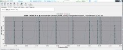
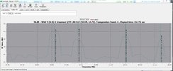
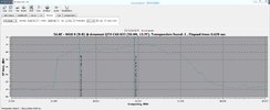
WGS9
Track satellite(s) WGS 9 (USA 275) and see where are they located now. Check when there will be the next pass over your location

www.n2yo.com
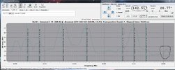
56.75 E
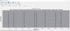
Intelsat - 5F4
INMARSAT 5-F4 is a geostationary satellite designed to beam Internet and data transmission capacity to airline passengers, maritime crews and military personnel. The satellite is the fourth member of Inmarsat's broadband communications fleet, a $1....
www.n2yo.com
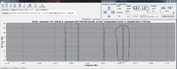
56.60E
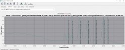
The positions will have an accuracy relative to the positioning of the two satellites, that is defined by the station keeping crew that are assigned to maintain efficiency of the fuel on board, with the caveat 'because there is little else out there, you can let it go if it saves a bit of propellant'.
Since both satellites are a good few 000 kilometers away from each other (in three dimensions) and there is not much else at the orbital locations, I would suspect they are happy to let a few hundredth of a degree slide if it means a few months more of downlinking.
Have you tried a smaller dish on the position ?